 |
The Grange Estate |
The historic Grange Estate is Haverford Township's ...
For more information on the Grange, including history, tours, activities, membership and rentals, go to the Friends of the Grange website (www.TheGrangeEstate.org).

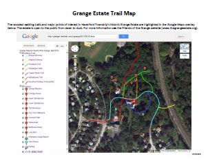
The following online Google Maps overlay shows the walking trails and major points of interest on the Grange Estate property. You can zoom in to see more details and pan around. The "Satellite" view shows the trails in relation to the woods, buildings and parking area. The trails are short and generally under the tree canopy. Other than the driveway, they are walking paths on unpaved natural surfaces. Some have steps.
|
Walking Trails Lt. Blue: Grange Driveway Yellow: Original Driveway Green: Woodland Trail Orange: Washington Walk Blue: Copper Beech Trail Brown: Springhouse Trail Red: Hav. Heritage Trail Major Features 1 Grange Mansion 2 Carriage House 3 Upper Springhouse 4 Lower Springhouse 5 The Necessary 6 Wm. Penn Milestone 7 Crescent Wall 8 Waterwheel 9 Bathhouse Ruins 10 Long Barn Tree: Champion Copper Beech Lt. Blue Pin: Farm House P: Parking Yellow: St. James Church |
Zoom in or out, pan in any direction, use Map or Satellite photo view View Larger Map |
Below is a link to a one-page pdf file of the Grange Estate map that you can print out. It shows the walking trails with their names and color codes, as well as the names and locations of the major features on the Grange Estate grounds.
Printable pdf Map Sheet)